
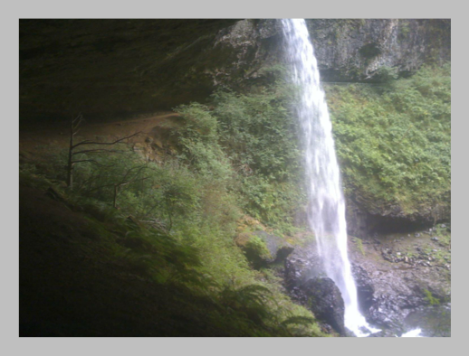
Base of Middle North Falls.
The odometer should be taken with a grain of salt or two… The loop that I hiked was listed as 8.7 miles. The canyon trail was, well, in a canyon and the GPS doesn’t like canyon walls. The other thing the GPS doesn’t like is rain. I’ll get back to that.
The day started out with some deer – a mother and two fawns were right outside the cabin when I got up. I even played ring around the car for a little bit (I was staying on the other side – not chasing, just keeping my distance). I got started on the trail at 11 am and decided to do the trail of the ten falls. Weather was a little overcast, but otherwise nice.
South falls was very impressive, and would be even more impressive in spring, with some more water. Being able to walk behind it was neat, though not picturesque. I also realized that the classic photo of it was taken a few years ago – one of the trees has grown a bit. Not bad yet, but in a few years from now it will become a significant issue for photographers.
Then off to Lower South Falls. This had some stairs marked on the map. The photo to the right doesn’t do them justice. There are more than a few of them. The waterfall itself was interesting, and I’d like to work with it some more in the future when I am not trying to do trail running. The waterfall itself was very nice, just had to watch out for blowing out the sky (overcast) when photographing it. It was another you could walk behind.
Then another mile and a bit to Lower North Falls. These falls are named after the position on the fork – upper, middle, lower – and the fork itself – north and south. There are a few others too, but they didn’t have too much imagination.
Along the way I saw a number of spiders. Not little things, but ones that could bite your head off. Not sure how big it is on your monitor, but thats about the right size on mine. Not a small beast.
Lower North Falls was ok. A bump with water going down it. A short jaunt up to Double Falls had a strong garden hose worth of water going over it (or so it seamed). However, the face where it hit the bottom was beautiful in the contrast between white water and black basalt.
Drake falls was a short distance, but couldn’t see much from the spot where you could see it.
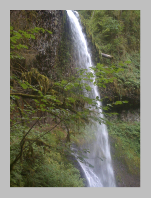
Then up to Middle North Falls. This was one I would have liked to spent some time at (again, next time when I’m not trail running). Only a little way down from the Winter Fall trail intersection. And you could go right beside it and behind it too.
On the way past it, I got my first sprinkle of a shower. Not much, but enough to briefly make me think of heading back along the Winter trail route. I pressed on.
Twin Falls might be fun to photograph, but it is hard to get to any place to see it where justice is done. Then a mile to North Falls. Here, mother nature decided I needed to know this was a rain forest. It rained a fair bit on me on that leg.
At North Falls, I sat behind the fall for a bit as I had a snack and drank a bit of water. Nice and dry, huge crescent behind the falls. Little bit loud, like living near an airport… but dry. I hiked out of there after a bit and was presented with more stairs.
When I got to the North Falls Trailhead/parking lot, I pressed on just a bit more to see Upper North Falls (only 0.2 miles each way). This is the waterfall I’ll head back to see tomorrow, time permitting. As a note, it is also reasonably flat to get there – A nice small waterfall with a beautiful face to it – water cascading over rocks. Its only a five minute walk there, if that (five minutes for me, after having hiked probably five something miles with a pack of camera lenses).
I took the Rim trail back from there and passed Winter Falls. It was raining then and more rain was falling on my head than over the brink. The about the waterfall says that it relies on winter runoff and is best in winter, spring and early summer… not autumn. Then another 1.6 miles and I was back at South Falls Day Use Area. It had been raining on and off on me, never hard but enough to remind me that I am wet. Good shoes kept my feet dry and the shirt and long sleeve T-shirt I had kept me fairly dry.
I wasn’t getting that cold until I was hiking back out and went through the parking lot with a wind blowing at me. That was where I decided tonight, I’m not cooking and that $40 was worth it.
It misted on me the way back and as I got back into my cabin, the skies opened and I type this now to the constant patter of rain on the roof. I’m glad its a roof and not a rain fly today. Its also wet enough outside that I’m not going to cook either, and instead am going to drive into town (Silverton) and have dinner there. Apparently, it has wifi and I can post this.
- N 44.87076
- W 122.65024
- Elevation 1360 feet
- Max Elevation 1553 feet
- Trip Odometer: 6.2* miles
- Odometer: 718 miles
codemore code
~~~~